
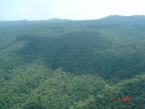
Mt. Marsabit is an ecosystem of vital importance for tens of thousands of people in Marsabit County in Kenya. A massive shield volcano covering an area of thousands of square kilometres and reaching to an elevation of 1707 m., it has a climate very different than the lowlands surrounding it. The mountain receives a mean annual rainfall of approximately 800 mm., as compared to less than 300 mm. in parts of the nearby lowlands. The Marsabit forest is a “mist forest”, receiving a significant portion of its moisture from condensation. The contribution of mist condensation to the water balance on the mountain has not been quantified but is certainly significant, giving the forest characteristics that one might not expect for an area receiving less than 1000 mm. of rainfall per year. Together, the precipitation and condensation received on the mountain provide water resources that are important to people and ecosystems not only on the mountain but also in the lowlands surrounding it. Mt. Marsabit, in other words, is a “water tower”—a source of runoff and groundwater as far away as the Chalbi desert.
However, Marsabit seems to have been suffering from an unsustainable rate of deforestation. From 19,000 ha. in the 1980s, the forested area has declined to about 11,000 ha. currently. Felling of trees for firewood, charcoal making and construction materials, conversion of forested areas to settlements and farms, and effects from livestock entering the forest have all played some role. The resulting loss of forest cover has contributed to degradation of water resources, with some boreholes and smaller springs drying up. This loss of forest is exacerbated by a vicious circle: as trees are removed there is less surface area for condensation from mist, which means less water entering the soil and the forest ecosystem, which in turn stresses the forest and hampers regrowth. Another factor may be the sinking of boreholes on the mountain, which is believed by some to be contributing to the degradation of water resources and ultimately to the drying up of the forest. Overall, if the trend of degradation continues, severe impacts for both human beings and wildlife can be expected.
© Lance Robinson
Parts of the mountain are gazetted as a National Reserve and also a Forest Reserve, and with these two types of designations comes the involvement of two different government agencies: the Kenya Forest Service (KFS) and the Kenya Wildlife Service (KWS). The ecosystem, however, extends beyond reserve boundaries and includes a substantial area of Community Land which falls under the management purview of local authorities. The County Council and Location-level Environmental Management Committees (EMCs) are also important actors in the governance environment. Although mechanisms for coordination have existed at the level of the entire District, there is little to nothing in the way of coordination, planning or management that focuses specifically on the level of the Mt. Marsabit ecosystem. A community forest association for the Marsabit forest has been formed but is not yet active.
With the devolution entailed in Kenya’s new constitution, significant changes in governance for the ecosystem can be expected. Other developments on the horizon include the creation of conservancies around some lower parts of the mountain and the likelihood that part of the current reserves will be designated as a National Park. National Park status will provide KWS with greater authority to prohibit people from entering the forest and making use of its resources.
Our assessment of governance for the Mt. Marsabit ecosystem focused on the system that existed prior to the new constitution and the devolved County system of government coming into effect. The process of creating and adapting institutional structures to conform to the new constitution is still underway, and we believe that this retrospective look at environmental governance as it was under the previous constitution will provide insights that stakeholders find useful as they chart a way forward.
Briefing Note: The Way Forward for Environmental Management and Coordination in Marsabit
Framework for Natural Resource Governance in Dryland Landscapes in Kenya
The assessment was led by Dr. Lance Robinson of the International Livestock Research Institute and also involved Dr. Joram Kagombe of the Kenya Forestry Research Institute. For more information, contact Lance Robinson: L.Robinson at cgiar.org